Aspen Acres Fire Holds at 99,077 Acres and 36% Containment as Crews Defend Rye
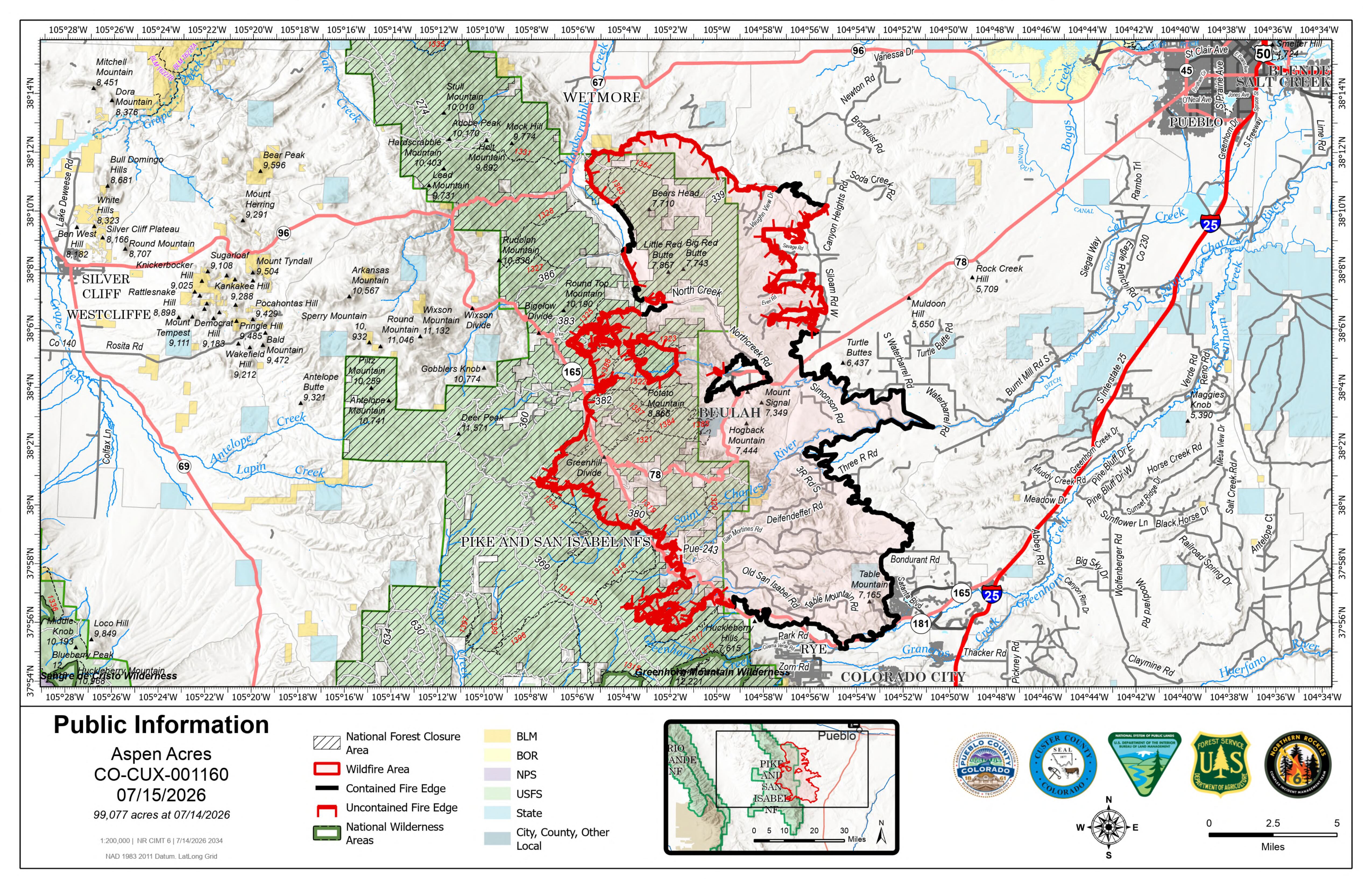
Description: The Aspen Acres Fire remains at 99,077 acres and 36% contained as 1,767 personnel strengthen firelines, protect structures and address active fire near Rye...

Location: 10 Miles NW of Rye, CO in Custer and Pueblo Counties
Start Date: Reported 06/29/2026 around 6:00 a.m.
Cause: Human, Under Investigation Size: 99,077 acres
Containment: 36% Total Personnel: 1,767
Key Message
At 6 a.m. the Northern Rockies Complex Incident Management Team 6 assumed command of the Aspen Acres Fire, led by Incident Commander, Rich Cowger. The team is honored to serve the communities on this fire.
Substantial work continued in the Mingus Ranch area during both day and night shifts on Tuesday. Firefighters worked on improving lines and extinguishing hot spots after the prior several days of strategic firing operations that removed fuels between the constructed line and the wildfire.
Fire activity was lower at Saint Charles Peak on Tuesday, while work continued on constructing primary and secondary firelines from the north to the south. Near San Isabel, crews made progress connecting portions of constructed dozer lines and hand lines. Structure protection work is complete on over 300 structures in this area. Aerial firefighting resources are working in conjunction with crews on the ground to keep the west side of the fire in check. Reconnaissance flights with drones routinely monitor for heat throughout the fire area.
Residents are eager to return home, but the high fire activity near North Muddy Creek remains a serious threat to the community, just 2 miles northwest of Rye. Firefighters have been aggressively constructing defensive lines between the fire and communities, working night and day shifts. The work is not yet complete and it is not yet safe for residents to return home. Winds aligned with drainages could rapidly send the fire towards Rye. Strategic firing operations began last night on the north flanks of this area of high heat, dubbed the "chicken foot," which is a critical step in removing fuels between the constructed lines and the wildfire. On the south side, crews are constructing direct line in effort to contain the fire. The structure protection group is also mitigating threats to properties in the Rye area and all along the west side of the fire, including other communities to the north and west. County Sheriffs and fire managers meet daily to discuss operations and evacuation levels. Everyone wants to see residents return home, but not before it is safe to do so.
Smoldering hot spots on the northeast side remain a lurking threat. The potential remains to ignite highly flammable juniper trees near a populated area. While residents are returning to their homes, firefighters continue to work in the area to reduce fire threats. They are running chainsaws to remove brush and lower tree limbs, working with hand tools, using engines, pumps, and water to cool smoldering hot spots. Watch for firefighters working in the areas of Savage Road, Even Road, Ponderosa Pine Drive, San Isabel Drive, Siloam Road, and others in this area. Please drive carefully, yield to firefighting traffic, and give room to crews working alongside roads and communities.
Weather and Fire Behavior
A high pressure system forecast to hold in the region through Thursday, with hot, dry, and breezy conditions. The wind pattern is expected to be from the east or east-southeast throughout the week. A chance of afternoon thunderstorms persists. As temperatures and winds increase in the afternoon, fire activity is expected to increase on the west side of the fire. Fuels remain extremely receptive to fire.
AREA CLOSURE
There is an Aspen Acres Fire Area Closure for the San Carlos Ranger District. Visit: https://www.fs.usda.gov/r02/psicc/alerts/aspen-acres-fire-area-closure . Please monitor land managing agencies for other fire restrictions. The National Forest Lands are closed and are also in evacuation status.
There is a Temporary Flight Restriction (TFR) in place above the fire area. Flying any aircraft within the TFR is prohibited. This includes the use of drones, or unmanned aerial systems.
Evacuations
All evacuations are managed by the respective county sheriffs. Monitor county social media pages or call county contacts for more information.
An Awareness status is in place for Fremont County, encouraging residents to stay informed, monitor official updates, and remain prepared.
In Pueblo County, evacuation status was lifted for the north and northeastern portions of the Aspen Acres Fire perimeter. Residents south of Highway 96 and North of Highway 78 are allowed to return to their homes. All residents will remain in pre-evacuation status and must be prepared to leave should conditions change. The fire remains active near North Muddy Creek, with potential to advance toward Rye. Thus, evacuation status remains on the south side of the fire. For Pueblo County evacuation information, call the Joint Information Center (JIC) at 719-583-4640; information about the Disaster Assistance Center (DAC) is also available.
Wetmore and Greenwood residents may return home; the area remains in pre-evacuation status. Other areas of Custer County affected by the fire remain in pre-evacuation and evacuation status. For Custer County re-entry questions or specific evacuation status, call 719-467-0271.
Huerfano County Sheriff's Office evacuated all areas within the National Forest to the East of where Williams Creek crosses into the National Forest and then following Williams Creek North to where Williams Creek intersects with CR 630 and following CR 630 generally north to where CR 630 intersects with CR 636 and continuing to follow CR 630 west to where it intersects with CR 634 (Gardner Road) and then running due North to the County Line. Southern and Eastern boundaries of the evacuation zone are the US Forest Service boundary and the Northern boundary is the County Line. For further information, call 719-738-1044 to reach Huerfano County dispatch.
Air Quality
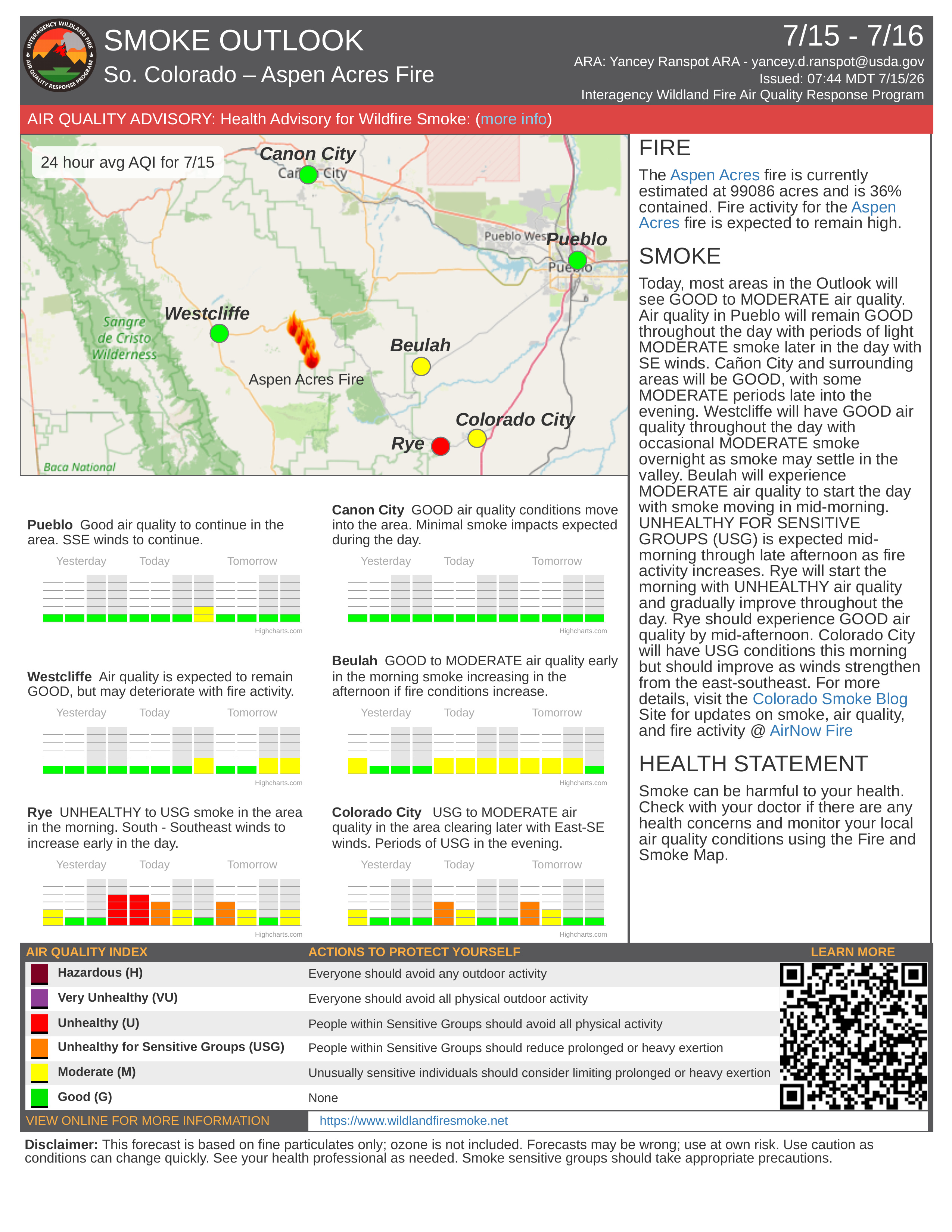
An Air Resource Advisor is assigned to the incident and assessing where communities may be impacted by smoke. To get daily air quality information, visit https://fire.airnow.gov/
The public and members of the media should monitor the following official websites:
www.puebloemergency.info, www.facebook.com/AspenAcresFire2026,
https://inciweb.wildfire.gov/incident-information/copsf-aspen-acres-fire,
https://www.youtube.com/@2026aspenacresfire
Follow Pueblo County Sheriff's Office Facebook at www.facebook.com/PuebloSheriff and X: @PuebloCountySO https://x.com/PuebloCountySO.
Follow Custer County Sheriff's Office Facebook at https://www.facebook.com/CCSOAdmin.
Follow SECO News on Facebook.
Subscribe to the SECO News YouTube Channel.
Click to Zoom
Press releases Sponsor




.png)


.png)
















.png)


.png)







