SECO 7 Day Forecast Jan 19-25th
Description: Provided by National Weather Service Office of Pueblo.
Published: 01/19/2022
Byline: Sperra

Today
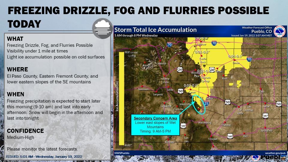
A slight chance of snow before 11am, then a chance of snow and freezing drizzle between 11am and noon, then a chance of snow after noon. Cloudy, with a high near 28. East northeast wind 10 to 15 mph. Chance of precipitation is 30%. New precipitation amounts of less than a tenth of an inch possible.
Tonight
A 40 percent chance of snow, mainly before 4am. Patchy fog after 1am. Otherwise, cloudy, with a low around 9. Wind chill values between zero and 5. East wind 5 to 10 mph.
Thursday
Cloudy through mid morning, then gradual clearing, with a high near 34. Wind chill values between -5 and 5. South wind around 10 mph.
Thursday Night
Mostly clear, with a low around 7. Wind chill values between zero and 5. South southeast wind 5 to 10 mph.
Friday
Mostly cloudy, with a high near 43. West wind 5 to 15 mph becoming north northeast in the afternoon.
Friday Night
A slight chance of rain and snow before 7pm, then a slight chance of snow between 7pm and midnight. Mostly cloudy, with a low around 15. North northwest wind around 10 mph. Chance of precipitation is 20%. New precipitation amounts of less than a tenth of an inch possible.
Saturday
Mostly sunny, with a high near 43. Northwest wind 10 to 15 mph.
Saturday Night
Mostly clear, with a low around 14. West southwest wind around 10 mph.
Sunday
Sunny, with a high near 55. West wind around 15 mph.
Sunday Night
Clear, with a low around 18. West southwest wind around 10 mph.
Monday
Sunny, with a high near 55. West wind 10 to 15 mph becoming north northwest in the afternoon.
Monday Night
Partly cloudy, with a low around 17. North northeast wind 10 to 15 mph.
Tuesday
A chance of snow. Partly sunny, with a high near 40. East northeast wind 10 to 15 mph.
Follow SECO Weather on Facebook.
Follow SECO News on Facebook.
Subscribe to the SECO News YouTube Channel.
SECO Weather Sponsor
.png)


.png)


.png)


.png)


.png)